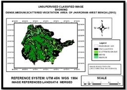
Vegetation Map:Forest density is a commonly collected attribute in management forest inventories. Forest density provides an indication of ecological attributes such as habitat potential,forest fragmentation, forest successional stage and regeneration success after a disturbance. Forest density is commonly applied as a stratifying attribute in models, such as those which estimate biomass or forest fire fuel types.As a consequence, density is included in the suite of attributes to be estimated from satellite data as a component of the NFI (et. al. Wulder).
- Dispersed Vegetation
- Dense Vegetation
- Medium Vegetation
Vegetation Mean Centre, 2013
| FID | Shape * | Id | XCoord | YCoord |
| 0 | Point | 0 | 502955.912305 | 2474233.02935 |
Table no1: Vegetation Mean Center,2013
Vegetation Mean Centre, 2018
| FID | Shape * | Id | XCoord | YCoord |
| 0 | Point | 0 | 502896.823381 | 2474362.07406 |
Table No2: Vegetation Mean Center,2018
Vegetation Statistics, 2013 to 2018
| Year | Low dense in sqKm | Medium dense in sqKm | High dense in sqKm | Total | |
| 1 | 2013 | 77.70 | 150.4 | 10.09 | 238.19 |
| 2 | 2018 | 78.16 | 142.13 | 13.81 | 234.1 |
Table No5: Vegetation Statistics, 2013-2018
Vegetation Decrease Statistics, 2018
| Year | Low dense in sqKm | Medium dense in sqKm | High dense in sqKm | Total | |
| 1 | 2018 | 8.09 | 5.30 | 0.056 | 13.45 |
Table No7: Vegetation Decrease Statistics,2018
Back